 Teixoso
Located on the slopes of Serra da Estrela, the parish of Teixoso is located about 8 km from the county seat. It consists of the village core and its annexes: Borralheira, Terlamonte, Gibaltar and Atalaia.
It is defined as a close link between the municipalities of Covilhã and Belmonte.
The settlement of the parish began in Roman times. Some traces of this period were found a few years ago in the territory. Responsible for its repopulation, after the Moorish landslides, was D. Sancho I, who in 1186 donated these lands to Covilhã. Teixoso is referred to in the 1396 Inquiries under the name of Teixuso, a toponym that has a geographical meaning and comes from the word yew.
The large number of yew trees that once existed in this region gave rise to the name of the village, the yew being a leafy tree that existed in one of the main entrances of the village, a specimen currently preserved in Quinta de São João.
In administrative terms, the parish was elevated to a village on March 8, 1928, thanks to the development achieved so far.
As for the parish institution, it must have taken place around the 13th century.
Sarzedo
It was a Portuguese parish in the municipality of Covilhã, with an area of 11.07 km² and 130 inhabitants (2011). Its population density is 11.7 inhab/km².
It was the seat of a small municipality extinct in 1836. It was composed of only one parish and had, in 1801, 430 inhabitants. It was incorporated in the municipality of Valhelhas between 1836 and 1855.
It was extinguished in 2013, as part of a national administrative reform, having been added to the parish of Teixoso, to form a new parish called União das Freguesias de Teixoso e Sarzedo.
Patrimony
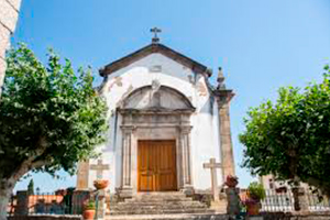
- Main church
- Santo Cristo National Monument
- Archaeological remains of Terlamonte
Other places of tourist interest
- Quinta de São João
- Our Lady of Carmo
- Chapel of St. Anthony
- Saint Mark’s Cross
- Chapel of Our Lady of the Greens
- Chapel of S. Salvador
- Archaeological find of the Barroca da Lage
- Remains of a Roman villae in Tapadinha