

MORAYS FROM THE NAVE OF SANTO ANTÓNIO
For the largest Glacier Valley in Europe, there are two possibilities to travel the entire route or simply make the journey by car, which is the most convenient and feasible for people with little time available.
Pedestrian path: Duration: 5h05min Distance:15km
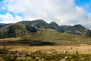
Leave the Tower by the trail to the East, passing by the ruins of the cable car and going down between zimbrais and cervunais to Covão do Ferro where the Padre Alfredo Dam is located. Go around the Dam through the steep slope. Pass through Covão da Mulher and go up to Nave de Santo António. Here, imagine an 80m high glacier constantly flowing over the peripheral valleys and carrying the rocks from the Plateau da Torre with you as if it were a treadmill. In a late phase of the glacier, these rocks were installed between the cervunal forming this landscape of extreme beauty, from which stands out the Poio Judeu, with its 150 m3, guarding the Glacier Valley. Travel the Nave de Santo António down the road to Covão da Ametade where you can enjoy support for the fantastic camper in the heart of the Biogenetic reserve. You must be very careful with this place. Follow the path indicated and enjoy the wonderful view that now follows. Pass by Covão da Albergaria in the valley’s sinuosity and start to observe the great “backbone” that seems to divide the valley in two. It is the Espinhaço do Cão formed by the glacier from the Vale da Candieira. Just ahead, the water line presents us with the beautiful view over Covões. Following through the predominant pastures on the banks of the Zêzere River, pass through Caldas de Manteigas towards Manteigas where the trail ends, but your tour does not…
Car Route: Duration: 20min Distance: 13km
Exit the Tower towards Covilhã. Pass the Cântaro Magro with its 1,928m of altitude sculpted by the action of the glacier and, just ahead, pass by Nossa Senhora da Estrela sculpted by the man himself. Follow curves and counter-curves until you come across a 150m3 block called Poio Judeu. This was transported by the ice tongue from the Nave de Santo António to this location at a late stage of the glacier. Go around the Nave de Santo António passing through the trail that descends from the Tower and head towards Manteigas. Notice the hundreds of blocks that settled there from the glacial plateau and that later flowed into the peripheral valleys. Continue on the road and start going down the Zêzere Glacier Valley. In the first winding curve on the right is Covão d’Ametade. Follow the route passing through Covão da Albergaria in the sinuosity of the valley and start to observe the high “backbone” that seems to divide the valley in two with its huge deposits in the abrupt slopes. It is the Espinhaço do Cão located below the Vale da Candieira, making it easy to understand the path that the glacier took. Going down a little further, you will see the water lines that cascade from the area of Covões, corresponding to a magnificent and exclusively glacial landscape. Ahead, pass through Caldas de Manteigas and proceed to the village of Manteigas where the route ends. Unlike your tour that is just beginning…
